 We have reached the mid-way point of the 2024 Atlantic Hurricane Season and it’s the perfect time to look back at all the weather systems that have passed through the region.
This year’s hurricane season, which spans from June 1 to November 30, is forecast to be above normal with a range of 17 to 25 total named storms.
So far, we have seen seven named storms, four of which have become hurricanes.
Tropical Storm Alberto
Alberto was the first tropical storm of 2024 developing on June 19.
It was the latest first named storm since 2014.
The storm primarily impacted Mexico, dumping heavy rainfall on the states of Coahuila, Nuevo León, and Tamaulipas in northeast Mexico. Rainfall from Alberto resulted in four deaths in Mexico and several millions in damage.
Hurricane Beryl
The most devastating storm so far this year was Hurricane Beryl.
Beryl was the second named storm, developing into a tropical depression on June 28 about 1,970 km east-southeast of Barbados. The storm experienced a rapid period of intensification due to warm waters in the Atlantic.
Conditions continued to be favourable for Beryl’s development and the storm became a major Category Three hurricane.
On July 1, Beryl made landfall in Carriacou as a strong and dangerous Category four hurricane with sustained winds of 150 mph (240 km/h).
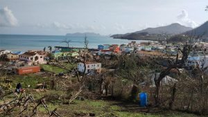
Beryl left a trail of destruction across the southern Caribbean with the islands of Carriacou, Grenada, Petite Martinique, Mayreau, Canouan, Bequia, Union Island and St Vincent receiving the most damage. Approximately 12 people were left dead in the aftermath.
Beryl’s rampage continued; the storm became a Category Five hurricane early on July 2. It was the earliest time for a category five storm to develop.
Beryl would later impact Jamaica, the Dominican Republic, Cayman Islands and the US mainland where it continued its devastation and destruction.
Over 70 people have died as a result of Beryl and over US$5billion in damage has been reported.
Tropical Storm Chris
On June 30, Tropical Storm Chris developed in the Bay of Campeche.
Chris was a short-lived storm dissipating early on July 1 as it made landfall and interacted with Mexico’s terrain. Rainfall from Chris caused flooding in several Mexican states and left one man dead.
Hurricane Debby
After a period of relative quietness in the Atlantic, the US National Hurricane Centre (NHC) began monitoring a tropical wavethat would develop into Hurricane Debby on July 26.
On August 2, the tropical wave started to develop an eyewall and was designated potential tropical cyclone four.
Deddy entered the Gulf of Mexico where it encountered favourable conditions to develop into a tropical storm.
The storm continued to grow in the favourable environment and became a hurricane on August 4 before making landfall in Florida.
Ten deaths and over US$1 billion worth of damage have been attributed to Debby.
Hurricane Ernesto
Ernesto was the third hurricane to develop this year.
The storm’s journey began on August 8 when the NHC began monitoring an area of low pressure in the tropical Atlantic.
By August 11, the system had organised into a low-pressure area and was designated Potential Tropical Cyclone Five.
Within 24 hours, it intensified into Tropical Storm Ernesto, which later strengthened into a hurricane on August 14. Ernesto continued to intensify, reaching Category Two status before weakening due to dry air and wind shear.
On August 17, Ernesto made landfall in Bermuda as a Category One hurricane but weakened into a tropical storm later that day.
B The storm caused significant disruptions and damage across several areas. In the Virgin Islands and Puerto Rico, over 700,000 people were left without power.
Hurricane Francine
Forecasters began tracking the low-pressure area that became Hurricane Francine on August 26 when it formed in the Central Tropical Atlantic.
The low-pressure became more organised, however, its development was initially hindered by unfavourable conditions.
On September 7, the wave entered the Bay of Campeche and was upgraded to a low-pressure area the following day. Due to its potential threat, it was designated Potential Tropical Cyclone Six on September 8. By September 9, the system organised into Tropical Storm Francine. As Francine moved northeast, it intensified rapidly, becoming a Category Two hurricane with winds of 100 mph by September 11. Francine made landfall in Terrebonne Parish, Louisiana the same day.
Francine was the fourth hurricane of this year’s hurricane season.
Tropical Depression Seven
NHC began monitoring the system that became TD7 when it was a trough of low pressure.
The trough interacted with a nearby tropical wave, which showed potential for slow development.
By September 11, the disturbance had become a tropical wave with showers and thunderstorms beginning to organise. Later that day, the wave developed a surface circulation, leading to its classification as Tropical Depression Seven.
Forecasters expect TD7 to intensify today and become a tropical storm.
