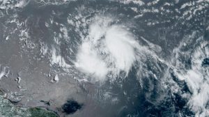
 Tropical Storm Bret grew stronger on Wednesday as it took aim at islands in the eastern Caribbean that braced for torrential rainfall, landslides and flooding.
Bret had maximum sustained winds of 60 mph (95 kph) early Wednesday morning and was moving westward across the Atlantic Ocean at 16 mph (26 kph), according to the National Hurricane Centre in Miami.
The storm was located some 505 miles (815 kilometres) east of Barbados and is expected to grow stronger before lashing several eastern Caribbean islands on Thursday at near hurricane strength. A tropical storm watch was in effect for Barbados, St. Lucia, Martinique and Dominica, as officials in the region urged people to prepare for Bret.
“We all know the uncertainty with forecasting intensity, movement and impact of weather systems,” Fitzroy Pascal at Dominica’s office of disaster management said.
The hurricane centre said it was too soon to know where Bret’s centre would pass through, but it warned that up to 10 inches (25 centimetres) of rain were forecast from the French Caribbean island of Guadeloupe south to Grenada and Barbados.
The government of Guadeloupe warned that inclement weather would start Thursday morning and continue until late Friday, with waves of up to 11 feet (3.5 meters).
“Be careful!” officials warned in a statement.
Bret is expected to weaken after it enters the eastern Caribbean Sea and is forecast to become a tropical wave soon after that.
The storm formed Monday — an unusually early and aggressive start to the Atlantic hurricane season that began on June 1.
A tropical disturbance with an 80 per cent chance of cyclone formation is trailing Bret. No June on record has had two storms form in the tropical Atlantic, according to meteorologist Philip Klotzbach at Colorado State University.
The National Oceanic and Atmospheric Administration has forecast 12 to 17 named storms for this year’s hurricane season. It said between five and nine of those storms could become hurricanes, including up to four major hurricanes of Category 3 or higher.
