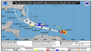
 Tropical Storm Elsa strengthened into a hurricane early Friday, and it still has Florida in sight for early next week, although the National Hurricane Center stressed that the forecast is uncertain this far out.
Closer targets, like the Lesser Antilles, are undoubtedly in the path of the storm. They’re bracing for several inches of rain and winds as strong as 75 mph, with higher gusts.
In South Florida, officials overseeing the search-and-rescue effort at Champlain Towers South are keeping an eye on Elsa as a possible disruption. At a Thursday evening news conference, Miami-Dade Fire Rescue Division Director Charles Cyrille urged residents to check their hurricane supplies
“Contingency plans for this incident are in place should this system become a threat to Miami-Dade County,” he said. “Now is the time to prepare.”
How strong is Elsa? Where is it going?
As of the 8:30 a.m. Friday update, Elsa was a hurricane, with maximum sustained winds of 75 mph and higher gusts that stretch up to 140 miles from the center, mainly to the north. Hurricane-force winds extended 25 miles from the center. Elsa was about 40 miles west of Barbados and about 75 miles east of St. Vincent.
The 8:30 a.m. update included revisions to the first 36 hours of the hurricane center’s forecast but not the long-range forecast, which the hurricane center said would come later, likely around the 11 a.m. update.
It was still moving west quickly. Forecasters said its rapid pace — 28 mph — could destabilize the storm and stop it from strengthening into a hurricane in the days to come.
Elsa is forecast to pass near or over portions of the Windward Islands or the southern Leeward Islands before moving across the eastern Caribbean Sea late Friday before moving near the southern coast of Hispaniola on Saturday. By Sunday, Elsa is forecast to move near Jamaica and portions of eastern Cuba.
It’s forecast to near Florida by Monday or Tuesday.
“There is a risk of storm surge, wind, and rainfall impacts in the Florida Keys and portions of the Florida Peninsula early next week. However, the forecast uncertainty remains larger than usual due to Elsa’s potential interaction with the Greater Antilles this weekend. Interests in Florida should monitor Elsa’s progress and updates to the forecast,” the hurricane center said.
The next 24 hours — on the runway to Haiti, the Dominican Republic and Jamaica — Elsa is set to travel over some storm-friendly conditions: warm sea surface temperatures, high humidity and low shear.
“Since the new forecast is a little higher than the previous one and shows peak winds just below hurricane force on Saturday near Haiti, tropical storm warnings have been issued for portions of the Dominican Republic and Haiti and a hurricane watch is now in effect for the southern portion of Haiti out of abundance of caution,” forecasters wrote.
St. Vincent and the Grenadines Prime Minister Ralph Gonsalves shut down the country Friday because of Tropical Storm Elsa. The country, already dealing with an active volcano that forced the displacement of thousands recently, came under a hurricane warning as of 8 a.m. Friday.
Listen to today’s top stories from the Miami Herald:
Subscribe: Apple Podcasts | Spotify | Amazon Alexa | Google Assistant | More options
A hurricane warning is also in effect for Barbados and St. Lucia. Martinique remains under a tropical storm warning. A tropical storm watch is in effect for Grenada and its dependencies, Saba and Sint Eustatius and Jamaica.
Parts of Hispaniola could see 4 to 8 inches of rain this weekend with isolated totals of 12 inches, the hurricane center said. That’s enough to cause flooding and mudslides.
Haiti under alert as Tropical Storm Elsa approaches. The Dominican Republic also watching
A split path
From there, the models are split. Some show a path east, over the Bahamas and out into the Atlantic again. Others lean west, with a path over Cuba and into the Gulf of Mexico. Forecasters stress that this part of the track has high uncertainty this far out.
“The degree of land interaction with the mountainous islands of Hispaniola and Cuba will be a big factor in the future strength of Elsa at days 4 and 5. Like the track forecast, there is a huge model spread with solutions ranging from dissipation in the Caribbean to a category 3 hurricane,” the hurricane center said.
Forecasters added: “Given the larger-than-normal uncertainty and because hazards will extend well away from the center of the storm, users are urged to not focus on the exact forecast points.”
Even the strength of the storm is hard to call at that distance.
Listen to today’s top stories from the Miami Herald:
Subscribe: Apple Podcasts | Spotify | Amazon Alexa | Google Assistant | More options
Tropical Storm Elsa is the earliest ‘E’ named storm on record, beating out Edouard in 2020. Normally, according to NOAA data, the average fifth named storm forms on August 31. The only storm that’s formed farther east this early in the season was a tropical storm in 1933, an infamously active season, according to University of Miami Research Professor Brian McNoldy.
It also became the first hurricane of the season, something that NOAA data show usually occurs on August 10. It’s the earliest first hurricane of the season since 2021, McNoldy tweeted.
NOAA predicted 2021 would be another above-average hurricane season but nowhere near 2020’s record-breaking status.
